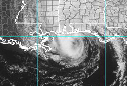
TROPICAL STORM ARLENE
By Ivan James

Photos By NOAA
HEADLINES.....
ARELEN IN THE GULF
At 1PM(EST.) Saturday The National Weather Service has predicted Tropical Storm Arlene to be near North Latitude 30.0 and West Longitude 87.5 located 20 miles South - SouthEast of the of Gulf shores of Alabama.
Tropical Storm Arlene is Moving North at 14 mph with sustained winds gusts at 60mph.
Arlene is to move closer to the coast later this afternoon and move into the Coastal areas of Florida and Alabama later tonight which the warned areas will be seeing some effects of this topical storm Later this Evening.
Tropical force winds can extend from center outward extend to150 miles. These winds extend the north and east of the center.
Arlene rain acumulations of 3 to 6 inches of rain in any given period or higher. Areas affected would be around the eastern and central gulf coast northward throught the tennesee valley and into the lower to the middle Ohio Valley.
***WACTHES IN EFFECT***
___________________________
TROPICAL STORM WATCH
IS IN EFFECT FOR THE NORTHERN GULF
COAST FROM MORGAN CITY LOUISIANA TO INDIAN PASS FLORIDA. A TROPICAL
STORM WATCH MEANS THAT TROPICAL STORM CONDITIONS ARE POSSIBLE IN
THE WATCH AREA DURING THE NEXT 36 HR.
__________________________
A TROPICAL STORM WARNING
THE NORTHERN GULF
COAST FROM GRAND ISLE LOUISIANA TO THE MOUTH OF THE PEARL
RIVER...INCLUDING THE CITY OF NEW ORLEANS AND LAKE
PONTCHARTRAIN...AND ALSO FROM INDIAN PASS FLORIDA EASTWARD TO
OCHLOCKNEE RIVER FLORIDA.
______________________
Hurricane Warning Areas *
CENTRAL GULF COAST FROM PASCAGOULA MISSISSIPPI
EASTWARD TO DESTIN
FLORIDA.
_________________________
Hurricane Watch Areas*
FROM THE MOUTH OF THE PEARL RIVER EASTWARD
TO WEST OF PASCAGOULA
MISSISSIPPI...AND ALSO FROM EAST OF DESTIN FLORIDA EASTWARD TO
INDIAN PASS FLORIDA.
________________________
*****NOTES*****
WHAT DOES THESE WARNINGS MEAN !!!
HURRICANE WATCH
MEANS THAT HURRICANE CONDITIONS ARE POSSIBLE WITHIN
THE WATCH AREA ...GENERALLY WITHIN 36 HOURS. HURRICANE WARNINGS
WILL LIKELY BE ISSUED FOR PORTIONS OF THE WATCH AREA LATER THIS
MORNING.
A HURRICANE WARNING MEANS:
THAT HURRICANE CONDITIONS ARE EXPECTED
WITHIN THE WARNING AREA WITHIN THE NEXT 24 HOURS. PREPARATIONS TO
PROTECT LIFE AND PROPERTY SHOULD BE RUSHED TO COMPLETION. A
HURRICANE WATCH MEANS THAT HURRICANE CONDITIONS ARE POSSIBLE
WITHIN THE WATCH AREA ...GENERALLY WITHIN 36 HOURS.
DISCLAIMER!!! JAMCOR BROADCAST.COM cannot and will not guarantee the availability or timely delivery of data and the server this should not be used to support operational observation, forecasting, emergency or disaster mitigation operations - public or private.
Copyright © 2004 JAMCOR INC. TM All Rights Reserved.
Material contained here may not be reproduced, broadcast, published, rewritten or redistributed with out express permission.